ETS Event of Summer 2019
Deep Tremor News: Spring - Summer. 2019
This BLOG-like page is being generated in a form similar to previous ETS ones to document and provide information on a Northern Washington ETS that should start sometime between April and May, 2018. There are no special experiments in the field for this ETS. We will be tracking and reporting on this ETS using data only from the real-time regional networks (UW, UO, CN, PB, CA) and/or information reported to us by others.
Produced by Steve Malone, PNSN Professor Emeritus
ETS dates:
Start: Aug 11, 2019
END: Aug 25, 2019
Start again: Nov 7, 2019
End again: Nov. 27, 2019
Information will be posted on this page (latest at the bottom) and references to figures from time to time.
NEWS (latest is at the bottom):
Apr. 8, 2019 - As of right now the expected main Puget Sound - Vancouver Island ETS event is probably still several months away. It should start in July-Aug plus or minus a month if the interval between events stays similar to the past and depending if it starts in Puget Sound (earlier) or Vancouver Island (later). However, this blog is starting early because there has been tremor activity in the spring of 2019 that has some characteristics of a Puget Sound ETS event. Many observers have been questioning if this is a classical northern-Washington ETS event taking place very early. As of now, we think it is NOT but rather is a strange inter-ETS sequence of tremor. A "regular "Observations" report has been posted with some thoughts about what we (I) think may be taking place. This current ETS blog will be updated in the summer when the real thing gets going.
Apr. 11, 2019 - Oops. I discovered some problems with my "regular "Observations" page I posted a few days ago and have had to post an "Oops, retraction/correction Observation" page in response. More will continue here as this situation develops.
Apr. 15, 2019 - I just add a bit more here even though the main northern Puget Sound ETS has not yet gotten going. The southern Puget Sound and southern Washington has continued to have some tremor. After a brief pause in tremor activity from Apr 9 -11 tremor again picked up on Apr 12 and has continued to slowly migrate south. As mentioned in the "regular "Observations" page and a previous Observations page by Mouse Reusch one of the central Oregon ETS events propagated north into southern Washington a little over a year ago. Current tremor activity is overlapping this area just northwest of Portland right now. The main Oregon ETS events in the past have had inter-event times of almost two years, thus the current activity extending into Oregon again seems too early if it is covering some of the same region. Time will tell.
May 16, 2019 - Tremor bursts have continued to excite and confuse all of us tremor watchers over the past month; but still I don't think we have seen the start of the regular 14 month northern Washington-Southern BC ETS patch. Below I show the wech-o-mter tremor locations for Apr 12 - May 15 color coded by time (blue - oldest, red - latest). It is far from obvious that there has been a normal, mostly unilateral progression of tremor up or down the region. Rather tremor has jumped around with significant batches concentrated in an area for a while and then either moving a bit or dying out.
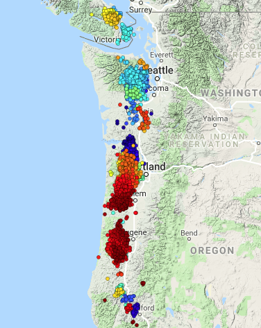
There are even small patches up on Vancouver Island and down near Medford, OR. The strongest batches seem to be from Seattle south a ways, one in northern Oregon and another recent and continuing one in central Oregon. There seems to be enough tremor in these batches to represent significant slow slip. Remember that Aaron "tremor-man" Wech believes and states that ALL tremor represents slow slip. It is just not observable on GPS data until it goes on long enough.
So, at the risk of being booted out of the ETS seismologists club I decided to pretend that I was an ETS geodesist. With some careful checks (I really don't know enough to know what to check) I have analyzed a bunch of data from GPS stations in the region to try and determine where and how much slip was going on. My data sources are basically from the very good PANGA web site that presents processed and de-trended displacement data for a huge number of sites all over western North America. I also used a private data repository and display interface from the Cascade Volcano Observatory for some presentations. In the following map I show the locations of what I interpret to be the recent (March-May) displacements or slow-slip movements (red circles) and the locations where I don't see any such displacements (magenta squares). The small yellow circles are the locations of stations for which there was no data or the data were too noisy to decide one way or another if there was motion.
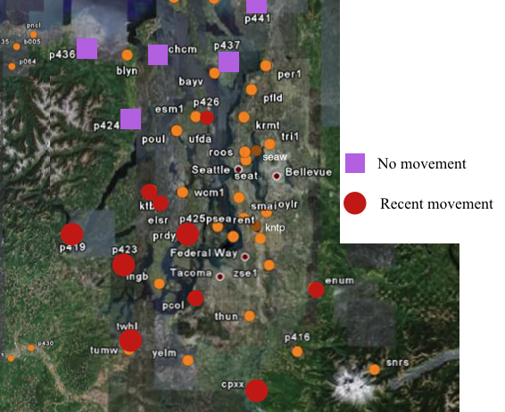
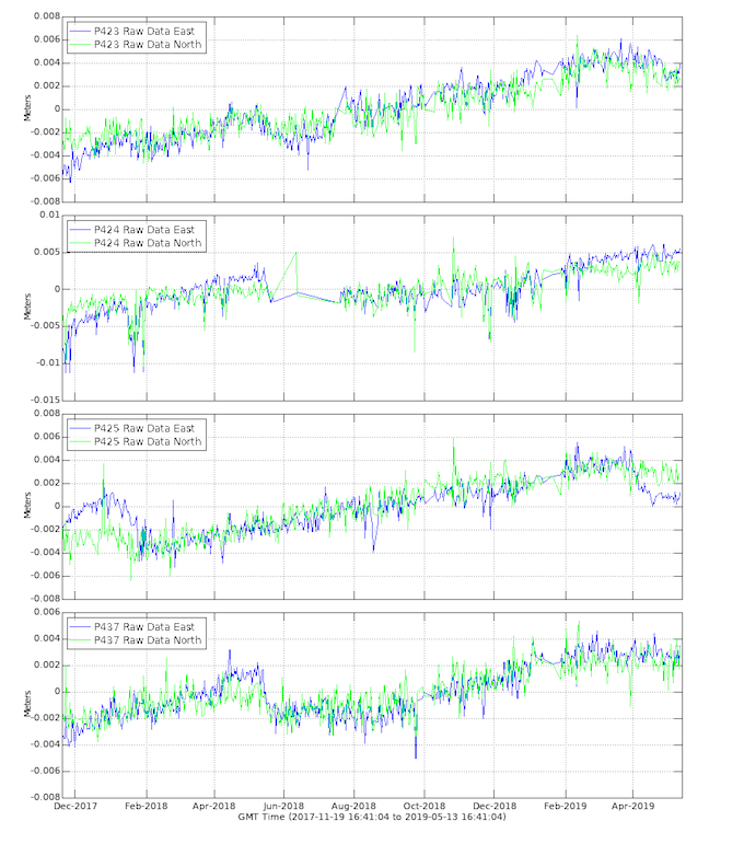
One can look on the PANGA web page for these station and decide for oneself if this seismologist is interpreting geodetic data reasonably well. But as examples of a couple of stations that clearly show movement (P423, P425) compared with a couple that don't (P424, P437) I provide the following time series for the last 18 months of their data. Note that in all four cases one can easily see the previous ETS events (Jan, 2018 in the south and Apr, 2018 in the north).
Based on this seismologists attempt at being a geodesist I will claim that one or maybe several ETS events are taking place to the south of Seattle but that the "main" one north of Seattle has not yet started. This, of course begs the question about this southern movement being too early. Indeed, central Oregon ETS events have tended to be on about a two year cycle in the past so this is almost a year early if that is what it is. I have not attempted to looks at the GPS data in Oregon myself but suspect that it might show slow slip going on there now. I will leave that as an exercise for the reader and keep my attention more focused on the traditional 14 month ETS area.
BTW (By The Way) A heads up! Dr. Professor Wech has been working hard on a new wech-o-meter over the past several months. It and its new web interface may be ready for releasing to the public soon. Stay tuned for exciting technical developments, if not geophysical ones.
May 22, 2019 - NOTE: The new tremor location and display system is released as of noon today. Check it out in the same old place at pnsn.or/tremor and also a complete description of why, how and what in our Observations blog.
Not much new regarding where or what the tremor is doing. It continues as of yesterday now in south central Oregon but may be near the end of its run. We now wait on something really getting going in northern Washington and/or southern Vancouver Island, maybe within a month.
May 28, 2019 - Indeed the central Oregon tremor bunch seems to have recently gotten much weaker; however some have noticed that there has been again tremor in the Olympic mountain area (northern Puget Sound region). Yep, but. probably not the beginning of the expected MAIN northern Puget Sound - Southern Vancouver Island - 14 month ETS..... probably. It seems with tremor jumping around in different places looking like it's really going to take off it can be confusing. I am confused but then I often am. However, I am also patient and still waiting for the real thing to start. Of course, as Dr. Wech of the new Wechometer-2 says: "all tremor represents slip". I agree, but still am intrigued with the fairly regular schedule this 14-month batch has taken in the past and so am waiting for it to be about 14 months since the last one before screaming "it has started".
BTW, speaking of the Wechometer-2 (it is pronounced in only two syllables, "weh - cometer" rather than the previous version that was a "wech - o - meter") it has been running now for almost a week and we feel it is working well. However, we are also interested in your impressions. Please fill out the google form survey with your comments and/or impressions (raves are encouraged).
Aug 13, 2019 - No I don't think that the main Puget Sound ETS has started... but it is probably getting close. Just to let readers know that I am not asleep I am updating this blog with a few general comments.
The new Wechometer has now been running for going on three months without a major glitch. There were a couple of short down-times but these were mostly due to the seismogram server from which it gets data. This server had to have some major upgrades and security enhancements and getting it back-on line broke a few things that were not caught as soon as they should have. As someone who tries to keep the Wechometer configurations up-to-date I should have caught it sooner. However, the basic system itself is so robust it lulls me into a less than vigilant state. Thats a good thing and a bad thing.
BTW, 75 people responded to our request for user feedback. Only a few of the comments were obvious trolls generally bad mouthing everything, usually in poor English. The general impressions given in the responses were divided with just over a third positive, just over a third negative and less than a third neutral. Of course all of the troll comments were in the very negative category.
Surprising to me was that most of the negative comments complained about no longer having the “realtime” version. It seems a significant subset of users want to be able to look at tremor locations change over the course of today. Of course, this option was never truly “realtime”; it was just a cut-down, crude version running hourly rather than once a day. It was often in error with lots of bogus locations and often missing tremor because of latent data feeds. I guess some people like to get garbage fast rather than higher quality results with a delay. We will not bring back that garbage producing old version; however we will look into what it would take to update the new tremor system more frequently; maybe twice or four times a day. Because of its design and need for possible latent data this may not be easy to do. BTW, it is currently updated daily at about 6 PM local Pacific Time. It done at this time because the current GMT day is over at either 4 PM PST or 5 PM PDT. Thus, if one checks in the evening here one gets the latest updated version of locations for that day (universal standard time which is what is always used by seismology).
There were a number of complaints about “missing” features, many of which actually do exist but the responder didn’t find or was confused in their use. When in doubt please use the “tour” (green button at top right) and or play around to see if the feature is not there but implemented in a different way than in the old version. Some features from before are actually still missing such as looking at the raw trace envelopes. We will review all the received requests for changes and/or features and see what can be added or changed to satisfy these suggestions. However, some suggestions are either not appropriate or probably beyond what this system can easily do.
Keep in mind that the PNSN and our colleagues studying ETS and tremor in particular have many more responsibilities. Primarily we are interested in earthquakes. Some respondents to our survey are confused by the difference. For earthquake locations see the “Recent Events” map. This is updated within minutes of any earthquake (if working as it should). The Tremor Map is not related to earthquakes. In fact there is an attempt to filter earthquakes out of it to use show just tremor locations.
In the meantime we wait for the start of the main northern Washington-southern British Columbia ETS.
This seismologist is at a loss to find unambiguous evidence of slow slip yet. There are a couple of GPS stations that may be hinting at motion, but it is far from clear thus far. Of course, a real geodesist might convince me otherwise.
Aug 29,2019 - AAARRRGGGH! Tremor quit early on the day after my last post. I was even up on southern Vancouver Island on a bicycle vacation hoping to watch (remotely) the tremor pass under me and it stopped as I started riding. This was not supposed to happen. Without at least two full weeks of strong tremor and associated geodetic motion it is inconsistent with a full blown ETS. There are a few GPS stations that seem to have a bit of motion that may be ETS related but it is far from conclusive. Colleagues here at the PNSN are trying to keep me calm by telling me "Don't worry, it will start again", but at this point who really knows. It may be over with an incomplete event.
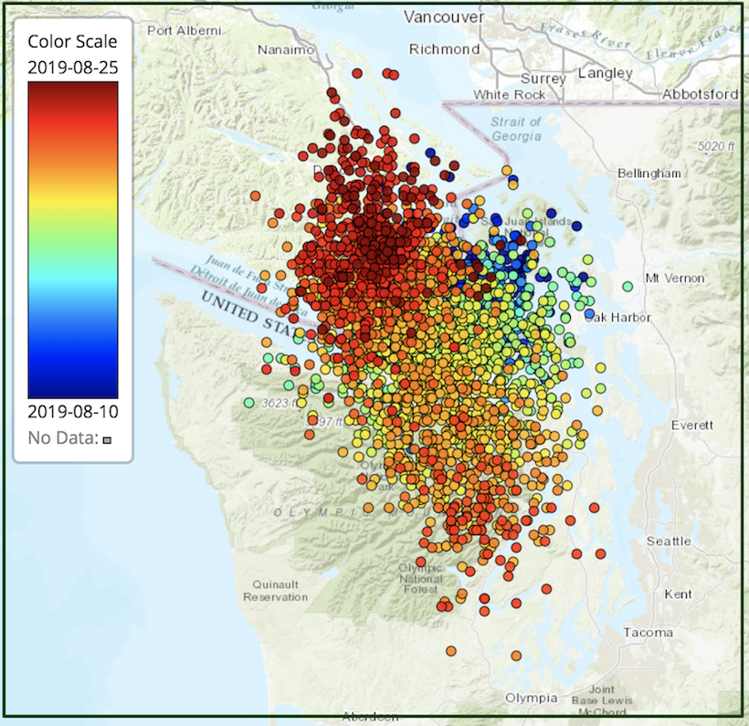
Sep 5, 2019 - OK, OK, it's time to give up on this ETS doing anything more. I am calling it over as of Aug 25. There is still a gap in recent activity north of Victoria on Vancouver Island, so when and how that gets filled in is anyone's guess. This whole sequence, from its start in the spring with scattered tremor and significant GPS displacements in northern Oregon and southern Washington to this latest endemic two weeks of tremor in northern Washington, has been somewhat different from what we have seen over the previous almost two decades (since good data for this region have been available). Of course, almost every sequence has had some differences from previous ones, so this latest difference should not be considered as some huge anomaly.
I should finish up this blog sequence now with some comments about some things I have learned, though not of a geophysical nature. There still seems to be a great deal of interest in the whole ETS phenomenon. Over the past several months we have had many requests from both private citizens and from the news media for interpretations, reactions or comments on what is going on. Some news reporters, in particular, seem to feed off each other generating stories about how the tremor increases the chance of a large earthquake.
There are two reasons why this writer (me) thinks this notion is not worth reporting. The first is that it is only a hypothesis that the slow slip taking place in the down-dip portion of the subduction zone (well established by the data) could increase the stress on the locked portion (not established by any data) and that this increased stress might trigger a big earthquake. The second reason is that even if the hypothesis were true, since an ETS is going on somewhere in Cascadia most of the time, there is no reason to think that the Washington one is special and would be the one to trigger a large earthquake. Why not the one in northern California (average repeat time of 11 months), or the one in central Oregon (repeat time of 22 months), or the irregular one on northern Vancouver Island, or one of the ones that spans two common regions such as the one last spring in northern Oregon - southern Washington? Because we have the longest record of studying the northern Washington - southern Vancouver Island ETS (repeat time 14 months) the news media gets excited when it comes around and goes bonkers about increased hazards. Maybe some day the science will have progressed to the point of understanding the significance of ETS, but I for one do not worry more about earthquakes during ETS than in between them.
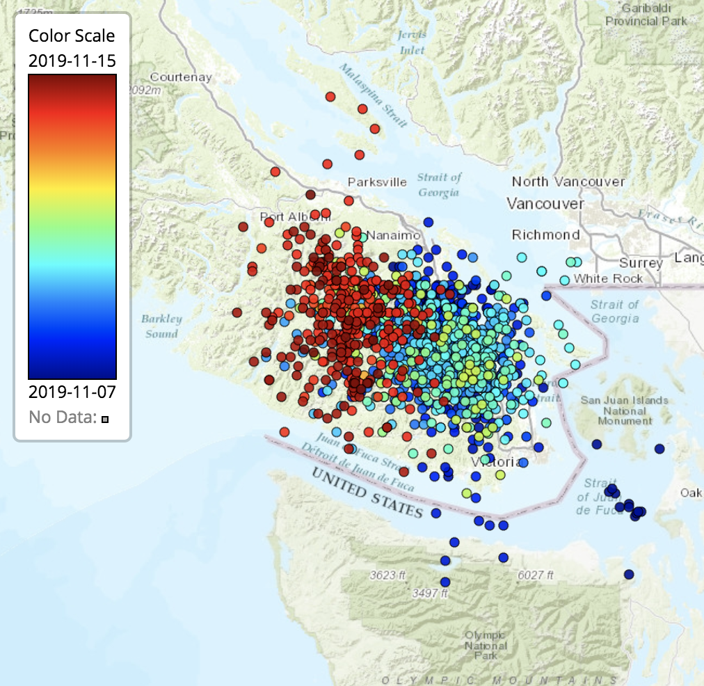
Nov. 15, 2019 - I was not going to add anything to this blog; HOWEVER, it looks like tremor is going again, this time just north of where it left off back in August. Maybe this is finishing off the standard ETS that seemed to give up back then and will now fill in the missing section up to the middle of Vancouver Island. So far it has been going for just over a week, which is the duration I have used as an indication that it is the real thing and not just a small inter-ETS bit of tremor. Of course, as Wech says, all tremor represents slow slip in the some area, but those that can be easily recognized from the geodetic motions are the ones we traditionally call "real" ETS events. The standard (in the past) 14 month one seems to have been split into three different ones none of which fall into the standard 14-month version. This whole slow slip thing keeps being interesting and not predictable but someday.... we may understand it.
Here is the first 8 days of this latest batch color coded by time. It started just north of Victoria and seems to be moving up Island just like a good ETS should. I'll give it at least another week to see if it fills in the whole expected zone.
Nov. 24, 2019 - Almost 10 days later and it is still going on. This is the real thing. However, while it started out pretty much as expected (moving up Island at about 10+ km per day) after a week it stopped heading north and quickly went back south. The past couple of days tremor has been back in southern Vancouver Island not far from where this batch started. Though the latest is obviously up-dip (south-west) of the original bunch back on Nov. 7. It has now pretty much filled in most of the 14-month ETS area (central Puget Sound to central Vancouver Island) and may be winding down. Let's see if it can keep going to the south, back into the US where there may be a bit of slip deficit left from the anemic events of this past summer. I am not nearly skilled enough to try and interpret any GPS data that could help resolve how much slip has occurred where. I will leave that problem as an exercise for the reader.
Dec 4, 2019 - OK it's done. I am calling it over about a week ago on Nov. 26, or 27. It still did not act all that normal. It did slowly move up island for about a week but never had much strong tremor at the north end. It then sputtered along with bits of tremor here and there including ending up with a moderate amount of tremor back where it started near Victoria. Go figure.
BTW the bits of tremor locations strong out to the south into Puget Sound we suspect are not real tremor but artifacts of a combination of noise sources. The wech-o-meter is usually quite good about recognizing such and weeding them out but it still can be fooled. Looking at the original data I don't see anything that I would immediately recognize as tremor at those times but then my eyes could fool me.
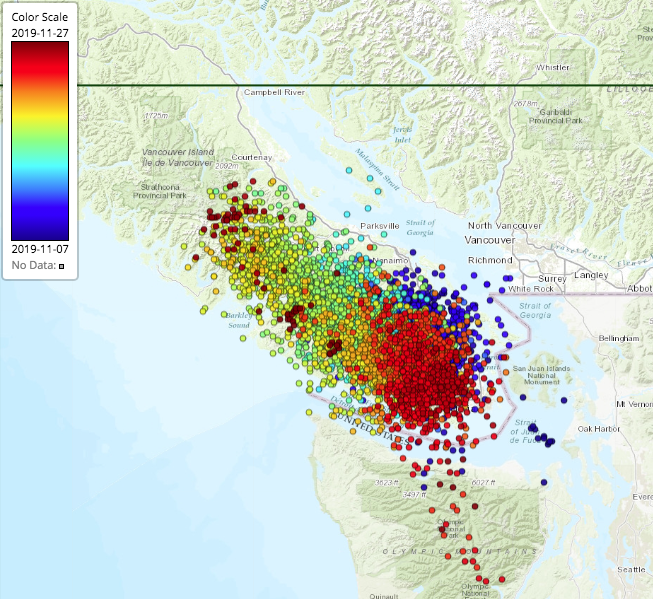
Here is a complete tremor map of this region for the latest batch (Nov 7 - Nov 27, 2019) color coded by time:
While the GPS data have not all been processed and are not yet available to me in a easy to plot form here is a cut out of some relevant stations provided by PANGA on their summary plots for the past year. All of these stations are in souther BC. Many show a clear departure (down) from the average trend starting in early to mid November. Stations UCLU, BAMF and SC04 have particularly strong signals and others also show some changes.
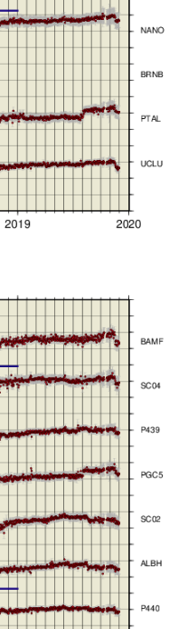
This confirms that this was an energetic enough ETS for this seismologist to even see it on geodetic data. Real geodesists can probably model these data for the location and size of slip on the megathrust fault. My back-of-the-envelope estimate for the size of the whole section that slipped starting late last spring in southern Puget Sound might be the equivalent event of magnitude 6.8.... but that is a wild guess.
I am now calling this absolutely over and will go back to sleep for another 12-14 months.