RAC Meeting 2003
Meeting Materials/Presentations:
Minutes of ANSS Pacific Northwest Regional Advisory Committee
January 23, 2003
University of Washington, PNSN labs
Review of ANSS Funding and Plans
Malone: ANSS status is about the same, waiting for Congress to pass budget. Since there are now hundreds of installed ANSS stations some of the budget will be allocated for maintenance. The PNSN will likely install 15-20 ANSS stations in 2003; 9 instruments have already been ordered.
Part of the PNW ANSS plans call for an array of instruments in the South Seattle/Duwamish area. This array was intended to consist of reference sites but there was some confusion at the federal level such that the array might be for structural monitoring. Otherwise, the PNSN may install up to 20 instruments by the end of summer 2003. The 2004 budget is still being finalized, but substantial new funding by Congress is unlikely.
Washington State support for seismic networks
Dave Nelson: The Washington State Seismic Safety Sub-Committee reported back to the Emergency Management Council that created it, a list of policy recommendations for the council to act on and advance to the Governor. Included in the high priority items presented to council was a recommendation that the State of Washington fund the PNSN to help support information product development and the delivery of information to end users. Steve Malone, Craig Weaver, and Tim Walsh were invited to make presentations to the EM Council describing the hazard, the ANSS plan, and why State support is critical to it's success. The talks were well received and the EM Council Executive Committee will discuss how to proceed with the recommendations in their March meet
Review of current PNSN status
Thomas: PNSN is operating 83 3-component strong motion sensors, where 80 of these are in real-time telemtry. The majority of these are ANSS, as indicated by the following summary of funding:
• 48 ANSS
• 20 USGS/UW
• 12 CREST
• 3 DOGAMI
---------
• 83 Total
Recent installations are the free field CREST stations at Mt Hood and at Forks, Washington. PNSN staff will be performing siting activities from January through April.
Review of Structures Subcommittee
Hooper: The subcommittee is still in the process of identifying appropriate locations. Free field stations will provide the most useful data. John will be attending a meeting with PEER and will examine the possibility of using their portable passive instrumentation for use in the PNW.
Savage has developed a 3-page draft Guidance document that will be formed into a proposal for the ANSS National Steering Committee. This will give clear instructions for site selection for structural monitoring. Guidance is needed by ANSS personnel for decision making regarding which structures to instrument. Every ANSS region should have a clear statement by the March meeting of the National Steering Committee about their concerns. The draft document needs to be reviewed by the PNW structures subcommittee as soon as possible with comments sent to Woody Savage.
Malone recommends that the guidance document include considerations for real-time data collection, not simply the traditional mode of post-event data processing for future design. Plans should have more national scope and not just a California perspective.
Savage: Priority should be to identify needs and then select locations that meet the needs. This is an alternative to the standard method of just picking structures and then making the data fit the needs. There likely will be some sort of national overseer for regional projects to make sure that both regional and national needs are met in any given structure. Since real-time monitoring of structures is a new area, some methods will have to be developed for collection and analysis of such data.
Eberhard: What about management of meta-data, such as properties of structures? Are such data available.
Savage: There has been some reticence on the part of some owners on releasing sensitive drawings. It might be possible to make arrangements with owners for non-public access to meta-data.
Eberhard: Another option is to look at a more restrictive set of meta-data such as the 40 fields used in HAZUS. Since this is less detailed then maybe owners would permit access to such data.
Hooper: You need drawings. They are important.
Crouse: Is there an inventory of available data?
Wong: For Portland, yes.
Weaver: For Seattle also, but the data are hard to get. HAZUS overestimated the damage for Nisqually due to the lack of real instrumentation.
Serra: HAZUS data for Everett, and probably other cities, is outdated.
Strong-motion data cooperation discussion
Savage: We are currently making efforts to coordinate between Frankel's group and the NSMP in rapidly sharing data to end users. Issues are mostly technical. Would like a more specific example of needs from regions for how to do more cooperation.
Crouse: For Frankel's array we should always have current locations available and be notified in advance of plans to move stations. Some of the permanent ANSS South Seattle/Duwamish array stations should take over Frankel's sites as he vacates them.
Frankel: Agrees that local interests can be kept better informed of their plans. A couple of sites that should be permanent are the Harbor Island Site (HAR) and the 4th and Holgate station (SDS). As ANSS moves into South Seattle, the emphasis of the temporary array may shift towards a more dense array. This may take a couple of years to transition. There has been some pressure from management to remove stations. The station duration is determined on a case by case basis with most stations operating for around 2 years.
Malone: Station locations are one aspect of cooperation. Is waveforms a separate issue?
Savage: NSMP is working on event compilation. Frankel's data is not always available through the NSMP data center. Smaller events may not be worth the effort of putting into the NSMP site. The ideal is to have all the data available in a central location.
Frankel: There should be an ANSS data center compiling all waveforms (NSMP, Frankel's data, ANSS). Current ANSS Web site serves PR purposes only.
Savage: CISN is developing an example of a regional data center. We may want to separate the data centers into a "raw" area and a value added area.
Malone: Data from some regional networks go to IRIS. However, IRIS is not going in a direction of added value for enhancing engineering data sets.
Weaver: It's very important to have a centralized data set, including the smaller events and including all types of data. How would I look for smaller events if there are several different data centers? It needs to be centralized.
Frankel: The whole point of ANSS was to integrate the strong motion and weak motion data sets. IRIS is not perfect; for example it was hard to find Denali data. There is a concern over loss of identity and loss of funding if ANSS data goes to IRIS.
Crouse: There has been a lot of talk for a number of years about organizing strong motion data but its still not there. The lack of budget is not a real excuse. This issue needs to be prioritized; there is a need to set aside budget and manpower. There is a need to have a plan and just do it.
Weaver: This should be a national system.
Malone: The TIC plan addresses this issue and there is a subcommittee of it which may still be working on it, but there has been no recent motion.
Frankel: Harley Benz indicates that there might be some plan.
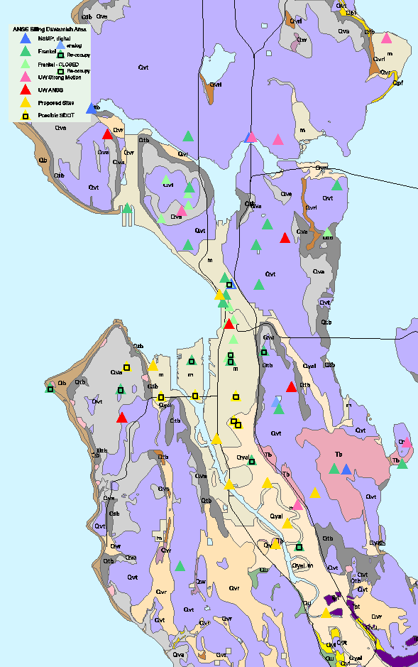
Siting for 2003
General plan is to reoccupy sites that recorded '65 and '49 events, reoccupy selected Frankel's stations based on his advice, and to install a South Seattle/Duwamish valley array possibly using wireless telemetry as needed. There should be fund to install on the order of 12 ANSS stations. Weaver reported that he understood that the City of Seattle DOT has purchased 3 K2 instruments which can also be used in this array, preferably at sites of particular interest to DOT.
A discussion by many participants aided by both street and geologic maps resulted in a specific list of sites with some priority for their installation. During the coming year (and depending on ANSS extra funding) we will install an east-west line at the following sites: Frankel's Alki Point (ALK), two SDOT sites in West Seattle, Frankel's Harbor Island Site (HAR), Frankel's site at 4th and Holgate (SDS), Frankel's Beacon Hill site (6 sites total). Additional Duwamish sites are the Army Corp of Engineers/WASHDOT facilities (site of recording of the 1965 earthquake), Frankel's Boeing Field site (BOE), and the SDOT site across the river from BOE. Another possible site to the south is the SDOT facility near bedrock north of Allentown (or else put the site directly on the bedrock). It was proposed that two of the Duwamish sites have boreholes for site characterization and down-hole sensors. Sensors will be strong motion sensors, not pizometers. Several people advocated including pizometers if at all possible but recognized that these probably don't fall under the ANSS plan directly. Additional target areas are North Seattle/Shoreline/Edmonds area, a Yakima station, and a site in Eastern Oregon possibly Baker or LaGrande. Another option for Oregon is the new OEM facilities in Salem that will be occupied by March. Siting for the Yakima site will be coordinated with Steve Palmer's site characterization studies (see below).
Cooperative information products (DOT-bridges)
Eberhard: A proposal has been submitted to utilize the capabilities of ShakeMap and known bridge vulnerability curves developed by Civil engineering to rapidly generate probabilities of damage to bridge structures following an earthquake. The proposal includes upgrading Shakemap to make it automatic and include improved geology and combine its output with DOT bridge parameters. The proposal has been accepted but funding of it is still pending and would not start until summer in any case.
Perkins: Geology for ShakeMap needs to be checked in many places. For example, geology for downtown Seattle is classified as "E", modified soil, is not be appropriate. This may have come from misrepresentative sampling from the Denny Regrade area. Darienzo will check with Rose Gentry for O-DOT interest in updating ShakeMap capabilities for Oregon.
Site Characterization Studies
Two site characterizaton proposals have received funding. Ivan Wong has received funding from NEHERP to characterize 25-35 sites where strong-motion instruments recorded the Nisqually earthquake. He provided a list which includes both NSMP and PNSN stations. He already has Vs values for about 100 sites in the greater Seattle area and the new study will use a similar technique (SASW analysis). Plans include bringing in a Vibroseis truckand recording systems from Texas. He is interested in the research project of using his analysis to predict Nisqually ground motions and to compare amplification factors with NEHERP amplification factors, with a goal of improvement of the latter. The plan is to get imaging down to 200-300 feet. His current data from 100 sites is in the final preparation stage and should be publically released within weeks.
Steve Palmer from the State Department of Natural Resources expects funding from FEMA to do site characterizations at up to 100 sites using surface methods and 10 boreholes. He reported that funding was not yet secure and that permitting issues for the boreholes could be a big sticking point. Discussions within the group were encouraging to have two of the boreholes in the Duwamish area, at sites, 4th and Holgate (SDS) and Army Corp of Engineers/WASHDOT site. These could then be used for down-hole instruments. Palmer reports that his proposal will need to be modified since the use of the holes would be different than originally proposed.
(NOTE, a week following the meeting Palmer provided the following information:
He has received word from FEMA that his project has been funded and so will be going ahead with plans and expects some drilling to take place starting this summer. A detailed description of the project follows:
The Washington State Department of Natural Resources, Geology and Earth Resources Division has received funding through the Hazard Mitigation Grant Program (HMGP) for the Nisqually Earthquake to develop statewide liquefaction hazard and NEHRP soil-type maps. Regional earthquake hazard maps such as these support hazard mitigation, emergency planning and response, local zoningordinances, and building code enforcement. Production of these hazard maps will benefit the mitigation and response efforts of the Pacific Northwest Seismographic Network (PNSN) in their implementation of the Advanced National Seismic System (ANSS) in two distinct ways. First, the NEHRP soil-type map can be incorporated into the production of ShakeMap, and will result in a more accurate representation of regional ground shaking after an earthquake. Also, the geotechnical drilling and shear wave velocity surveying conducted during this investigation will be located so as to characterize the ground motion response at a number of PNSN/ANSS recording sites. This calibration is crucial to providing accurate ShakeMap presentations, and is important information used by geotechnical engineers involved in the design of earthquake-resistant structures throughout Washington state.
Partner recognition information on PNSN WEB page
Bill Steele has compiled a list of PNSN partner to both document and recognize the cooperative nature of the PNSN and to try to give credit to those who are helping. Details can be found at: https://www.ess.washington.edu/SEIS/PNSN/PARTNERS/welcome.html
Advisory committee attendees:
• Chair: CB Crouse, URS
• Steve Palmer, WA DNR
• Bob Zimmerman, Boeing Corp.
• Dave Nelson, WA EMD
• Marc Eberhard, UW Engineering
• Roger Serra, Snohomish County DEM
• John Hooper, Skilling Ward Magnuson Barkshire Inc.& Structures subcommittee chair
• Bill Perkins, Shannon & Wilson & Siting subcommittee chair
• Julia Shaughnessy, BPA
• Mark Darienzo, OR OEM (via phone)
Guests:
• Leon Kempner Jr, BPA
• Ivan Wong, URS Corp.
• Franco Albi, BPA
• Bob Norris, USGS Seattle
• Tony Qamar, PNSN
• Tom Yelin, USGS Seattle
OperationsGroup:
• Steve Malone, PNSN & ANSS Regional Coordinator
• Bill Steele, PNSN
• Craig Weaver, USGS Seattle
• George Thomas, PNSN.
• Woody Savage, USGS NSMP
• Art Frankel, USGS