RAC Meeting 2001
Meeting Materials/Presentations:
- First Meeting Notes
- Current Status
- Status Report (October)
- Draft Plan
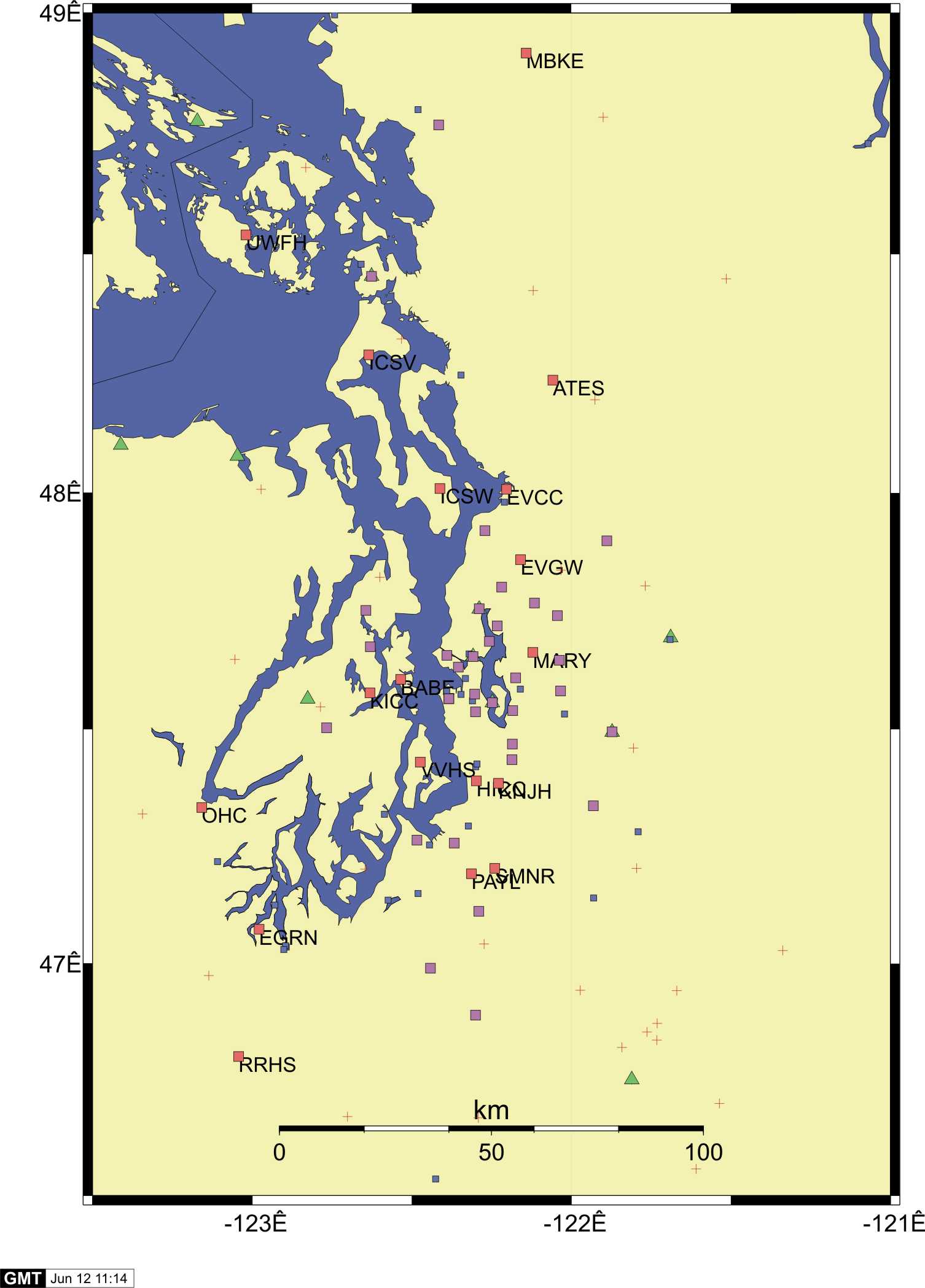
- Seattle Station Map
- Geologic Materials in the Everett-Seattle-Tacoma area
Minutes of ANSS Pacific Northwest Regional Advisory Committee
5 April 2001 (convened at the University of Washington Seismology Lab)
Meeting began at 9:15AM . The list of attendees is at the end of these minutes. Red text is related to action items, purple marks committee reminders to the PNSN.
Attendees:
COMMITTEE ADVISORS:
- C.B. Crouse, URS Corporation
- John Hooper, Skilling, Ward, Magnusson and Barkshire
- Steve Palmer, WA State Dept. Natural Resources
ANSS OPERATIONS STAFF:
- Sue Sweet, UW Seismology Lab
- George Thomas, UW Seismology Lab
- Kathy Troost, UW Dept. of Earth and Space Science
- Tom Yelin, USGS, Seattle
The following notes are compiled from SS, GT and TY. Responses to some of the suggestions and/or questions by the PNSN staff in the weeks following the meeting are supplied in italics following each section where appropriate.
- CB: Geotechnical data (shear wave velocity and drilling logs) are needed from station sites. Put stations at places where geotechnical information exists, e.g. federal buildings. Note-Sources of existing geotechnical data: SP, KT, Derek Booth, WA DOT, private geotechnical and engineering firms.
- KT: Has a database of borehole information from projects such as Seattle tunneling. Ivan Wong (URS Corp) used this database to make maps.
- PNSN staff will work on compiling what geotechnical information there now exists working particularly with Kathy Troost and Ivan Wong.
- SP: No seismic data collected for Kent and Puyallup Valley from Nisqually earthquake because there are no stations. Huge loss by not having stations. Unable to answer questions such as why there was a lack of liquifaction in these valleys. Need to put future stations here.
- Site selection for the next round of instruments as targeted two sites specifically in response to this suggestion.
- SP: Can do shear wave refraction tests on schools grounds, e.g. doing this in Federal Way.
- CB: Buildings can act as an LP filter. Contamination of ground motion records by building response is not a great concern if the building is 1-2 stories sitting on slab on grade.
- All reference sites PNSN has and will install follow this guidline if at all possible. Notes will be added to the station data base for any deviations from this situation.
- SP: Merge PNSN and NSMP stations, they are too distinct. Need to be consolidated into one database. Need one local contact for all stations in the region.
- Committee suggests that PNSN collect NSMP data in real-time.
- CB: Need better maps of locations which include all stations (PNSN & NSMP).
- All: Merge all seismic data, geotechnical data, etc. Need 'one-stop shopping' for all data. Users currently must go to 3 web sites (PNSN, NSMP, Frankel) to get all data and would prefer to only go to one centralized location (database). This database should have trace data and calibration data for all strong motion stations (PNSN, ANSS, NSMP and Frankel's). This database should also include any available geotechnical information about each site. Large scale (1:24,000) maps with the station locations marked could also be included. There should be one local contact person for questions.
- CB: Art Frankel (USGS-Denver) has seismic data for this area. Instruments have moved and will be moved again. Is there a database for his sites? What stations were where during past events? Need some permanent stations to address question of non-linearity of site response as a function of earthquake magnitude. Install ANSS stations as permanent replacements of Frankel's station after moving (south of Downtown. Note: Harbor Island-all shallow response). Steve Malone should email Art Frankel (CC Mark Peterson, USGS Denver?) to request a station location history and records of all earthquakes. Also check with Art Frankel about interest in going more Vs or borehole work on his or ANSS stations.
- Steve Malone of the PNSN has started an e-mail dialog with Art Frankel to address these two issues (summary database of all strong-motion stations and putting permanent instruments in some of his downtown Seattle sites.
CB: What is the specific language of ANSS coverage approved by congress? Are we limited to urban areas or is this interpreted? CB would like to expand coverage outside urban areas if possible, specifically to the coast on sites with varying soil classes. Note-First check the soil types and local geology at the four BPA sites slated for CREST installations.
- CB: Expressed concerns about T1 lines all going down at once in schools. Are there any more secure communication sites?
- Telemetry is a complex operational issue and is based on best available resources at reasonable costs. PNSN's different protocols are also historically based. The ANSS plan is to standardize as much as possible the protocols while maintaining some diversity in teleletry paths and techniques to make a more robust system. Loss of data at 4 sites during the Nisqually event was due to power failures at or near the remote sites. Our telemetry equipment at these sites did not have battery backup. We will be reviewing and correcting these problems in the future; however there is no way to guarentee that all parts of any telemetry system will be up through all earthquakes and thus we have on-site triggering and recording at all ANSS sites.
- SP: Do we really need real-time data? GT: Data recovery time would be too great without real-time. **Most important information to engineers is 5% damped acceleration response spectra. This is most important in real-time to determine shaking, it gives a rapid picture of building response.
- Rapid response is a major goal of the ANSS requiring real-time telemetry. It also increases the reliability of station maintenance and data recovery. The ShakeMap and associated software has the capability to generate these response spectra products. This capability will be added to the caculations at PNSN for future events.
- Committee would like to see downhole instrumentation (triaxial accelerometers and possibly pore pressure gauges-a hole would have 3 accelerometers at 3 different depths). Need depths into 1000 m/s material ideally or at least below liquefiable soils. TY-may cost up to $100k, an expenditure that ANSS might find prohibitive without supplementary funding.
- PNSN has no expertise nor funding for such a suggestion but will bring it up with the National Implementation Committee (NIC).
- CB/JH: Request portable instrument (3-component accelerometer with field software to get instant response spectra information) be deployed to measure ambient noise of mid- to high-rise buildings, primarily to find the fundamental period and compare with predictions. (JH- ultimately want to place ANSS seismographs in buildings with a variety of periods.) The committee recommends that some funds go to this, suggesting one person (perhaps a student) go from building to building on roof to collect data. JH can provide building locations and other specifications. Contact Marv Crumb of GeoSIG about donating an instrument.
- This issue as well as permanent building monitoring as part of ANSS has been discussed by the NIC. John Filson suggested such one-time experiements might best be done through NIST (NSF facility) rather than ANSS which is for monitoring.
- Committee prefers installation at sites that have geotechnical data or else get data. SP can do shear wave velocity measurements if given priority. Kathy Troost should also receive support to do soil classifications outside Seattle. CB: Future ANSS budgets should have adequate line items for the collection of this type of data. Note: Ivan Wong has done some geotechnical work outside Seattle, BPA has borehole data or at least Vs.
- JH: Shake map should be using a 'soil' attenuation relation. No rock-soil conversion. The best relations need to be analyzed. Appropriate characterization/classification of soil is needed. Current soil amplifaction factors come from CA. NEHRP 2003 building code provisions are due in April 2002. WA engineers may recommend that soil response factor be developed for WA that may be different from CA. Data from Nisqually earthquake may show this if analyized.
- PNSN does not have capability at this time to take this type of effort on directly but will stay open to either doing it or helping with it in the future.
Who in the seismologic/geologic/engineering communities might attempt an analysis of the data.
PNSN staff will explore option for officially requesting assistance from DNR for help with shear-wave velocities in some specific areas.
- PNSN is under the impression (from discussions with the ANSS National Implementation Committee) that all strong-motion station do NOT need to be within the highly urbanized area. Indeed some of our stations already are located outsite urban areas and some of the planned ones are as well. The need for good geographic coverage and geologic sampling allows for this.
SUMMARY OF TARGET STRONG-MOTION LOCATIONS FOR FY2001:
-
-Look to government buildings (e.g. city hall) for stations, not just schools.
- -Do not duplicate NSMP stations (MURR).
- -Olympia *ADD 1 STATION* on same geologic unit which underlie most of the structures damaged in the Nisqually earthquake (consult with SP). Do not duplication NSMP stations.
- -Coast (Oregon): *ADD 2-3 STATIONS* on variety of moderately stiff soils and rock including CREST stations.
- -Kent/Puyallup Valley: *ADD 3-4 STATIONS* -Sumner HS, Aylen JHS (SP has geotechnical data from this school),Kent JHS
- -Seattle Fault: *ADD 3 STATIONS* - (E & W of Seattle) Bainbridge Island, Kitsap along fault-Bremerton, south Port Orchard.
- -Downtown Seattle to south Elliot Bay (Duwamish): *ADD 3-4 STATIONS* - replace Art Frankel's. Put on fill and firm ground. e.g. Federal Building (new or old?)
- -Issaquah: *ADD 1 STATION* - Issaquah plateau or Issaquah Creek flood plain
- -Portland?
TOTAL: 12-15 station
PNSN already was well underway with siting when these recommendations came through. However we have gone back and both found and changed some of our original sites to match these suggestions. For example, we now have two sites in Kent/Puyallup valley with a possible third. We are getting soil information for the proposed Oregon CREST sites and are changing planned sites there in one case partly for this reason. Three sites east and west of Seattle are being added along the Seattle Fault. We are planning at least one site in down-town Seattle at a previous Art Frankel site. In Olympia we are having trouble finding appropriate sites in damage area with good telemetry.