M1.7 earthquake - 15.04 mi SSW from Mount Vernon, WA
Status: Reviewed
0 Felt ReportsReport your experience
Magnitude1.7Time2025/11/16 11:45:57 PM UTCDepth11.79 miCoordinates48.2043, -122.3782ID62205087
Origin
Statistics on estimate of an earthquake's location and time. For more info, see Earthquake Terminology.Orid
3362018Magnitude
1.69Time
1763336784.2999992Latitude
48.20433Longitude
-122.37817Depth
11.79 miLocation Quality
ExcellentEvent ID
62205087Event Type
eqGtype
lHorizontal Uncertainty
0.12 miDepth Uncertainty
0.3 miAzimuthal Gap
33 degNumber of Phases
68RMS Misfit
0.16Focal Mechanisms
Describes the fault orientation and slip direction of an earthquake and are generated using first motion (up or down) observations.Solution 1
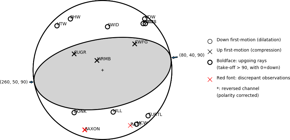
Number of P First motions: 15
| Plane A | Plane B | Uncertainty | |
|---|---|---|---|
| Strike | 80 | 260 | 70 |
| Dip | 40 | 50 | 20 |
| Rake | 90 | 90 | 30 |
Discrepant Stations
Stations whose observed first-motion does not match the predicted first-motion from the focal mechanism.| Station | Network | Channel | Polarity | Quality |
|---|---|---|---|---|
| SAXON | UW | HHZ | U | 0.9771 |
| RATT | UW | HHZ | U | 0.9243 |